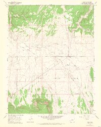
1964 Map of Basin
USGS Topo · Published 1968About this map
Dry Creek Basin dominates this portion of San Miguel County, where ranching life and rugged water management define the landscape in the mid-1960s. Small hubs of activity are centered around Beards Corner and the Young Ranch, while the small settlement of Basin sits near the intersection of several unimproved roads. The drainage network is complex, characterized by seasonal or intermittent flows like Dead Horse Creek and Nelson Creek, which carve through the high plateaus and canyons.
Find a feature on this map
19 named features on this map. Tap any name to fly to it.
Don’t see what you’re looking for? This feature index may not catch every label — zoom into the map to look around manually.
Map Details
Editions of this 1964 Basin Map
4 editions found
Other maps of this area

1916 · Paradox Valley
USGS Topo · 1:125,000

1922 · Paradox Valley
USGS Topo · 1:125,000

1948 · Naturita NW
USGS Topo · 1:24,000

1948 · Gypsum Gap
USGS Topo · 1:24,000

1949 · Gypsum Gap
USGS Topo · 1:24,000

1949 · Naturita NW
USGS Topo · 1:24,000

1956 · Cortez
USGS Topo · 1:250,000

1956 · Moab
USGS Topo · 1:250,000

1958 · Cortez
USGS Topo · 1:250,000

1959 · Cortez
USGS Topo · 1:250,000