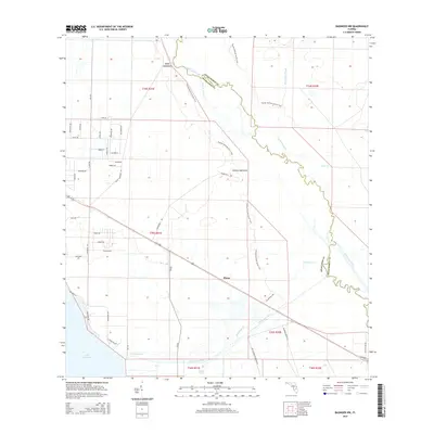
2015 Map of Basinger NW
USGS Topo · Published 2015About this map
The Kissimmee River forms a winding natural boundary between Okeechobee and Highlands counties in this 2015 survey. The landscape is defined by the transition from open wetlands and sloughs to the distinct hammocks that provided dry ground for early settlement. The Florida National Scenic Trail traverses this terrain, passing through Bluff Hammock and Hickory Hammock as it follows the river's eastern flank. The small community of Plains sits at a crossroads in the central section, reflecting the area's agricultural character near the Istokpoga Canal. To the southwest, the shoreline of Lake Istokpoga and the settlement of Lake Annie mark the edges of a vast hydrologic system. Notable local landmarks like Hole in the Wall and Starvation Slough provide insight into the historical vernacular of the Florida heartland.
Find a feature on this map
55 named features on this map. Tap any name to fly to it.
Don’t see what you’re looking for? This feature index may not catch every label — zoom into the map to look around manually.
Map Details
Editions of this 2015 Basinger NW Map
This is the sole edition of this map. No revisions or reprints were ever made.
Other maps of this area

1952 · Fort Kissimmee
USGS Topo · 1:24,000

1952 · Lake Placid
USGS Topo · 1:24,000

1952 · Lake Arbuckle SE
USGS Topo · 1:24,000

1952 · Lorida
USGS Topo · 1:24,000

1953 · Basinger
USGS Topo · 1:24,000

1953 · Fort Basinger
USGS Topo · 1:24,000

1953 · Basinger SW
USGS Topo · 1:24,000

1953 · Basinger NW
USGS Topo · 1:24,000

1953 · Fort Kissimmee SE
USGS Topo · 1:24,000

1956 · Fort Pierce
USGS Topo · 1:250,000