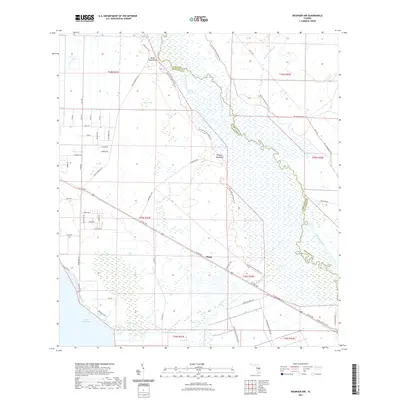
2021 Map of Basinger NW
USGS Topo · Published 2021About this map
The Kissimmee River meanders across this Central Florida landscape, defining the winding boundary between Okeechobee and Highlands counties. To the west, the massive expanse of Lake Istokpoga dominates the southwest corner, feeding into the Istokpoga Canal and Istokpoga Cr. The map captures a transitional rural environment where the settlement of Plains sits near the intersection of Co RD 700 and McArthur Rd. Distinctive local landmarks such as Bluff Hammock, Hickory Hammock, and the curiously named Hole in the Wall indicate the varying elevation and vegetation types typical of the region. The Florida National Scenic Trl bisects the terrain, following the river valley through areas like Starvation Slough and past Dinner Bay, while local routes such as Rattlesnake Hammock Rd and Basinger Grove Rd provide access to the agricultural interior.
Find a feature on this map
64 named features on this map. Tap any name to fly to it.
Don’t see what you’re looking for? This feature index may not catch every label — zoom into the map to look around manually.
Map Details
Editions of this 2021 Basinger NW Map
This is the sole edition of this map. No revisions or reprints were ever made.
Other maps of this area

1952 · Fort Kissimmee
USGS Topo · 1:24,000

1952 · Lake Placid
USGS Topo · 1:24,000

1952 · Lake Arbuckle SE
USGS Topo · 1:24,000

1952 · Lorida
USGS Topo · 1:24,000

1953 · Basinger
USGS Topo · 1:24,000

1953 · Fort Basinger
USGS Topo · 1:24,000

1953 · Basinger SW
USGS Topo · 1:24,000

1953 · Basinger NW
USGS Topo · 1:24,000

1953 · Fort Kissimmee SE
USGS Topo · 1:24,000

1956 · Fort Pierce
USGS Topo · 1:250,000