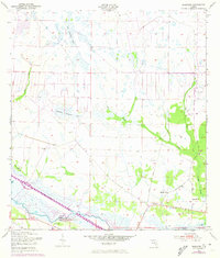
1953 Map of Basinger
USGS Topo · Published 1973About this map
Basinger sits at the heart of this landscape, a settlement defined by the winding course of the Kissimmee River and the expansive drainage networks of the central Florida interior. This 1950s survey, updated with 1970s aerial data, captures a transition in land use where traditional cattle country meets early water management efforts. Local life is anchored by the Basinger Sch, Brethren Ch, and the Basinger Cem, providing clear reference points for genealogists researching families from Okeechobee and Highlands counties. The terrain is a complex mosaic of hydrologic features, including Wolf Sawgrass Pond and various sloughs like Ash Slough and Gore Slough. Evidence of regional transport and infrastructure is seen in the S C L railroad line passing through Cornwell and the presence of a Gaging Sta and a small Landing Field.
Find a feature on this map
17 named features on this map. Tap any name to fly to it.
Don’t see what you’re looking for? This feature index may not catch every label — zoom into the map to look around manually.
Map Details
Editions of this 1953 Basinger Map
3 editions found
Other maps of this area

1952 · Fort Kissimmee
USGS Topo · 1:24,000

1953 · Taylor Creek NW
USGS Topo · 1:24,000

1953 · Basinger
USGS Topo · 1:24,000

1953 · Fort Basinger
USGS Topo · 1:24,000

1953 · Fort Drum SW
USGS Topo · 1:24,000

1953 · Basinger SW
USGS Topo · 1:24,000

1953 · Basinger NW
USGS Topo · 1:24,000

1953 · Taylor Creek SW
USGS Topo · 1:24,000

1953 · Fort Kissimmee SE
USGS Topo · 1:24,000

1956 · Fort Pierce
USGS Topo · 1:250,000