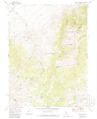
1969 Map of Basque Summit
USGS Topo · Published 1986About this map
The Old Overland Road traces a historic passage through the Desatoya Mountains along the border of Churchill and Lander counties. This high-altitude corridor is anchored by the Overland Mail Station (Ruins) and the Basque Summit, reflecting a landscape defined by 19th-century transit and livestock ranching. In the lower elevations, the Smith Creek Ranch sits near a Borrow Pit and a spillway, indicating the vital management of water in this arid environment. Indigenous history is also present on the landscape, noted by the Petroglyphs found near the banks of Edwards Creek. Numerous water sources like Topia Spring and Barrel Spring served as essential waypoints for travelers navigating the canyons and the expansive Edwards Creek Valley.
Find a feature on this map
28 named features on this map. Tap any name to fly to it.
Don’t see what you’re looking for? This feature index may not catch every label — zoom into the map to look around manually.
Map Details
Editions of this 1969 Basque Summit Map
2 editions found
Other maps of this area

1955 · Millett
USGS Topo · 1:250,000

1959 · Millett
USGS Topo · 1:250,000

1966 · Clan Alpine Ranch
USGS Topo · 1:62,500

1966 · Edwards Creek Valley
USGS Topo · 1:62,500

1969 · Cold Springs
USGS Topo · 1:24,000

1969 · Desatoya Peak
USGS Topo · 1:24,000

1969 · Carroll Summit NE
USGS Topo · 1:24,000

1969 · Carroll Summit
USGS Topo · 1:24,000

1969 · Basque Summit
USGS Topo · 1:24,000
1969 · Carroll Summit SE
USGS Topo · 1:24,000