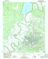
1988 Map of Bastrop
USGS Topo · Published 1988About this map
Bastrop serves as the focal point of this northeast Louisiana survey, shown during a period of significant municipal and industrial definition. The town is flanked by a complex hydrologic network, most notably the expansive Bussy Brake and the meandering Bartholomew Bayou that snakes through the western landscape. The presence of a dedicated Gas Field to the west and the Morehouse Memorial Airport to the southeast illustrates the post-war industrial and transportation infrastructure that supported the parish. Smaller outlying settlements such as Sheltons, Newblock, and Pt Pleasant provide critical points of reference for genealogists tracking local family histories in Morehouse Parish. The terrain is defined by its low-lying wetlands, including Thorny Brake, Squeeler Brake, and Mayhaw Slough, which highlight the traditional challenges and characteristics of the Bayou State landscape.
Find a feature on this map
20 named features on this map. Tap any name to fly to it.
Don’t see what you’re looking for? This feature index may not catch every label — zoom into the map to look around manually.
Map Details
Editions of this 1988 Bastrop Map
This is the sole edition of this map. No revisions or reprints were ever made.
Other maps of this area

1935 · Collinston
USGS Topo · 1:62,500

1935 · Naff
USGS Topo · 1:62,500

1935 · Drew
USGS Topo · 1:62,500

1935 · Haile
USGS Topo · 1:62,500

1955 · Jackson
USGS Topo · 1:250,000

1955 · Shreveport
USGS Topo · 1:250,000

1956 · Shreveport
USGS Topo · 1:250,000

1956 · Bastrop
USGS Topo · 1:62,500

1956 · Haile
USGS Topo · 1:62,500

1957 · Monroe North
USGS Topo · 1:62,500