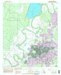
1994 Map of Bastrop
USGS Topo · Published 1995About this map
Bastrop serves as the primary hub of this north Louisiana landscape, surrounded by a complex network of wetlands and hydraulic engineering. The town's expansion is documented through provisional updates, showing residential growth near Newblock and Sheltons. The northeastern quadrant is dominated by the massive Bussy Brake, a water body defined by distinct levees, while the winding course of Bartholomew Bayou meanders through the center, separating the developed areas from the wilder western reaches.
Find a feature on this map
26 named features on this map. Tap any name to fly to it.
Don’t see what you’re looking for? This feature index may not catch every label — zoom into the map to look around manually.
Map Details
Editions of this 1994 Bastrop Map
This is the sole edition of this map. No revisions or reprints were ever made.
Other maps of this area

1935 · Collinston
USGS Topo · 1:62,500

1935 · Naff
USGS Topo · 1:62,500

1935 · Drew
USGS Topo · 1:62,500

1935 · Haile
USGS Topo · 1:62,500

1955 · Jackson
USGS Topo · 1:250,000

1955 · Shreveport
USGS Topo · 1:250,000

1956 · Shreveport
USGS Topo · 1:250,000

1956 · Bastrop
USGS Topo · 1:62,500

1956 · Haile
USGS Topo · 1:62,500

1957 · Monroe North
USGS Topo · 1:62,500