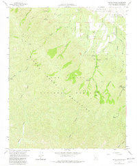
1964 Map of Bates Canyon
USGS Topo · Published 1982About this map
The Sierra Madre Mountains define this high-elevation landscape within the Los Padres National Forest, where a network of canyons and springs supported mid-century recreation and forestry operations. Traces of early land grants are visible in the northern section, which marks the holdings of the Cuyama (Maria Antonia de la Guerra y Lataillade) and the Cuyama (Heirs of Cesario Lataillade). The rugged geography is accessed primarily by the Sierra Madre Road and various jeep trails, connecting remote outposts like the White Oaks Guard Station. Local genealogy interests are anchored by the Foothill Cem located near the mouth of Cottonwood Canyon. Numerous primitive campsites, including Bates Canyon Campground and Cole Spring Campground, illustrate the area's development for backcountry use by 1964.
Find a feature on this map
32 named features on this map. Tap any name to fly to it.
Don’t see what you’re looking for? This feature index may not catch every label — zoom into the map to look around manually.
Map Details
Editions of this 1964 Bates Canyon Map
4 editions found
Other maps of this area

1902 · Santa Ynez
USGS Topo · 1:125,000

1905 · Santa Ynez
USGS Topo · 1:125,000

1905 · Lompoc
USGS Topo · 1:125,000

1912 · McKittrick
USGS Topo · 1:125,000

1937 · Branch Mtn
USGS Topo · 1:48,000

1941 · Caliente Mountain
USGS Topo · 1:62,500

1941 · McPherson Peak
USGS Topo · 1:62,500

1942 · Lompoc
USGS Topo · 1:125,000

1942 · Branch Mountain
USGS Topo · 1:62,500

1942 · Caliente Mtn
USGS Topo · 1:62,500