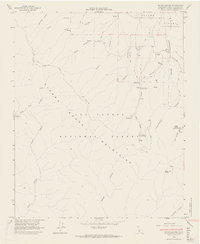
1964 Map of Bates Canyon
USGS Topo · Published 1965About this map
The Sierra Madre Mountains form a dramatic backdrop for this mid-century survey of the northern Los Padres National Forest. The map documents the intricate network of canyons and springs that define the local geography, including Mustang Canyon and Cottonwood Canyon. A complex system of land tenure is evident in the northern sections, where the boundaries of the Cuyama grants are clearly delineated, reflecting the region's heritage of Spanish and Mexican land claims.
Find a feature on this map
36 named features on this map. Tap any name to fly to it.
Don’t see what you’re looking for? This feature index may not catch every label — zoom into the map to look around manually.
Map Details
Editions of this 1964 Bates Canyon Map
4 editions found
Other maps of this area

1902 · Santa Ynez
USGS Topo · 1:125,000

1905 · Santa Ynez
USGS Topo · 1:125,000

1905 · Lompoc
USGS Topo · 1:125,000

1912 · McKittrick
USGS Topo · 1:125,000

1937 · Branch Mtn
USGS Topo · 1:48,000

1941 · Caliente Mountain
USGS Topo · 1:62,500

1941 · McPherson Peak
USGS Topo · 1:62,500

1942 · Lompoc
USGS Topo · 1:125,000

1942 · Branch Mountain
USGS Topo · 1:62,500

1942 · Caliente Mtn
USGS Topo · 1:62,500