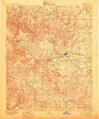
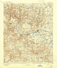
1891 Map of Batesville
USGS Topo · Published 1910About this map
The White River carves a deep path through the Ozark foothills, serving as the primary corridor for commerce and transport in north-central Arkansas during the late nineteenth century. Based on 1890 surveys, this area is defined by its numerous river crossings, including Walls Fy, Greenbrier Fy, and Ramsey Fy, which linked upland settlements like Cushman and Marcella to the regional hub at Batesville. The arrival of the St. Louis Iron Mountain and Southern railroad through the White River valley signaled a shift in logistics, yet the surrounding landscape remained dotted with family-named landmarks and rural outposts like Old Clem Place and Sterns Spgs. Beyond the river, the map reveals a rugged interior where communities such as Barren Fork (Drytown) and Loyal (Cave City) thrived near distinctive geologic features like Blowing Cave and Painter Bluff.
Find a feature on this map
75 named features on this map. Tap any name to fly to it.
Don’t see what you’re looking for? This feature index may not catch every label — zoom into the map to look around manually.
Map Details
Editions of this 1891 Batesville Map
6 editions found
Other maps of this area

1890 · Batesville
USGS Topo · 1:125,000

1890 · Mountain Home
USGS Topo · 1:125,000

1891 · Mountain Home
USGS Topo · 1:125,000

1891 · Batesville
USGS Topo · 1:125,000

1892 · Mountain View
USGS Topo · 1:125,000

1894 · Mountain View
USGS Topo · 1:125,000

1894 · Mountain Home
USGS Topo · 1:125,000

1932 · Strawberry
USGS Topo · 1:62,500

1935 · Strawberry
USGS Topo · 1:62,500

1935 · Newport
USGS Topo · 1:62,500