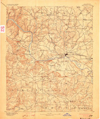
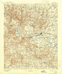
1891 Map of Batesville
USGS Topo · Published 1903About this map
The White River carves a deep valley through this Arkansas landscape, serving as the primary corridor for commerce and travel in the late nineteenth century. A series of historic river crossings, including Walls Fy, Grigsby Fy, and Gainer Fy, facilitated movement before modern bridges dominated the region. The map reveals a transition from the rugged highlands of Izard and Sharp counties down toward the lowland plains of Jackson county, with Batesville established as the regional anchor at the railhead of the St. Louis Iron Mountain and Southern RR.
Find a feature on this map
92 named features on this map. Tap any name to fly to it.
Don’t see what you’re looking for? This feature index may not catch every label — zoom into the map to look around manually.
Map Details
Editions of this 1891 Batesville Map
6 editions found
Other maps of this area

1890 · Batesville
USGS Topo · 1:125,000

1890 · Mountain Home
USGS Topo · 1:125,000

1891 · Mountain Home
USGS Topo · 1:125,000

1891 · Batesville
USGS Topo · 1:125,000

1892 · Mountain View
USGS Topo · 1:125,000

1894 · Mountain View
USGS Topo · 1:125,000

1894 · Mountain Home
USGS Topo · 1:125,000

1932 · Strawberry
USGS Topo · 1:62,500

1935 · Strawberry
USGS Topo · 1:62,500

1935 · Newport
USGS Topo · 1:62,500