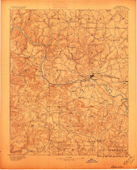
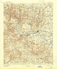
1891 Map of Batesville
USGS Topo · Published 1896About this map
White River navigation and early ferry crossings define this 1890 survey of the Ozark foothills. The river serves as the central artery for commerce, supported by numerous water crossings such as Gainer Fy. and Walls Fy.. These river links connected isolated settlements like Marcella and Cushman to the growing hub at Batesville, where the St. Louis Iron Mountain and Southern Ry. provided a vital connection to broader markets.
Find a feature on this map
71 named features on this map. Tap any name to fly to it.
Don’t see what you’re looking for? This feature index may not catch every label — zoom into the map to look around manually.
Map Details
Editions of this 1891 Batesville Map
6 editions found
Other maps of this area

1890 · Batesville
USGS Topo · 1:125,000

1890 · Mountain Home
USGS Topo · 1:125,000

1891 · Mountain Home
USGS Topo · 1:125,000

1891 · Batesville
USGS Topo · 1:125,000

1892 · Mountain View
USGS Topo · 1:125,000

1894 · Mountain View
USGS Topo · 1:125,000

1894 · Mountain Home
USGS Topo · 1:125,000

1932 · Strawberry
USGS Topo · 1:62,500

1935 · Strawberry
USGS Topo · 1:62,500

1935 · Newport
USGS Topo · 1:62,500