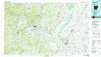
1986 Map of Batesville
USGS Topo · Published 1990About this map
The White River serves as the central artery for this mid-1980s landscape, winding past the regional hubs of Batesville and Newport. In the northwest, the terrain of the Ozark Mountains reveals a history of extraction at the Cushman Manganese Mines and Lafferty Manganese Mines, while the Missouri Pacific RR connects the riverside settlements. The map highlights educational and civic foundations, including Arkansas College and the Independence County Courthouse. To the east, the river system becomes more complex as the Black River and Cache River converge near Jacksonport State Park, an area defined by low-lying bottomlands and sloughs like Milligan Slough. The transition from the high ridges of Blue Mountain and Dean Mountain to the agricultural plains near Tuckerman and Alicia illustrates the varied geography of the Independence and Jackson county border lands.
Find a feature on this map
236 named features on this map. Tap any name to fly to it.
Don’t see what you’re looking for? This feature index may not catch every label — zoom into the map to look around manually.
Map Details
Editions of this 1986 Batesville Map
2 editions found
Other maps of this area

1890 · Batesville
USGS Topo · 1:125,000

1890 · Mountain Home
USGS Topo · 1:125,000

1891 · Mountain Home
USGS Topo · 1:125,000

1891 · Batesville
USGS Topo · 1:125,000

1892 · Mountain View
USGS Topo · 1:125,000

1894 · Mountain View
USGS Topo · 1:125,000

1894 · Mountain Home
USGS Topo · 1:125,000

1932 · Strawberry
USGS Topo · 1:62,500

1932 · Walnut Ridge
USGS Topo · 1:62,500

1934 · Powhatan
USGS Topo · 1:62,500