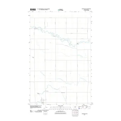
2011 Map of Bathgate
USGS Topo · Published 2011About this map
Bathgate anchors the southern portion of this landscape in Pembina County, situated just north of the Tongue River. The surrounding terrain is defined by a dense network of water management features, including County Drain Number 42, County Ditch Number 17, and County Drain Number 33, reflecting the region's intensive agricultural character. To the north, the Pembina River meanders sharply across the plains, its course marked by localized crossings like Morris Bridge, Kain Bridge, and Black Bridge.
Find a feature on this map
32 named features on this map. Tap any name to fly to it.
Don’t see what you’re looking for? This feature index may not catch every label — zoom into the map to look around manually.
Map Details
Editions of this 2011 Bathgate Map
This is the sole edition of this map. No revisions or reprints were ever made.
Other maps of this area

1939 · Cavalier
USGS Topo · 1:62,500

1941 · Cavalier
USGS Topo · 1:62,500

1941 · Bathgate
USGS Topo · 1:62,500

1952 · Thief River Falls
USGS Topo · 1:250,000

1956 · Thief River Falls
USGS Topo · 1:250,000

1957 · Thief River Falls
USGS Topo · 1:250,000

1964 · Neche
USGS Topo · 1:24,000
1964 · Cavalier
USGS Topo · 1:24,000

1967 · Thief River Falls
USGS Topo · 1:250,000
1970 · Bathgate SE
USGS Topo · 1:24,000