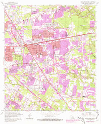
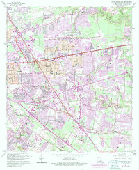
1963 Map of Baton Rouge East
USGS Topo · Published 1981About this map
The Comite River and several bayous define the eastern landscape of this Baton Rouge survey, which illustrates the rapid suburban growth following the mid-century. Significant residential expansions such as Broadmoor, Goodwood, and Castlewood are shown alongside the emerging commercial infrastructure of the Bon Marche Shopping Center. The map preserves the locations of numerous family-named landmarks and historical sites, including the Kleinpeter Cem and Harelson Cem, which remain tucked between expanding subdivisions. Industrial and transit hubs are clearly visible, from the Baton Rouge Depot to the Kansas City Southern and Illinois Central rail lines. Educational and spiritual centers like Woodlawn Sch and Rose Hill Ch provide essential anchor points for researchers tracing the mid-century development of East Baton Rouge Parish.
Find a feature on this map
62 named features on this map. Tap any name to fly to it.
Don’t see what you’re looking for? This feature index may not catch every label — zoom into the map to look around manually.
Map Details
Editions of this 1963 Baton Rouge East Map
5 editions found
Other maps of this area

1906 · Bayou Sara
USGS Topo · 1:125,000

1908 · Baton Rouge
USGS Topo · 1:62,500

1934 · Denham Springs
USGS Topo · 1:62,500

1939 · Zachary
USGS Topo · 1:62,500

1939 · Denham Springs
USGS Topo · 1:62,500

1939 · Baton Rouge
USGS Topo · 1:62,500

1942 · Watson
USGS Topo · 1:31,680

1953 · Baton Rouge West
USGS Topo · 1:24,000

1953 · Plaquemine
USGS Topo · 1:24,000

1953 · St. Gabriel
USGS Topo · 1:24,000