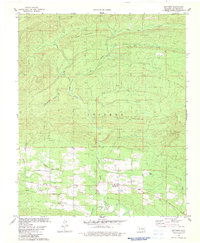
1982 Map of Battiest
USGS Topo · Published 1983About this map
The West Fork Glover River and East Fork Glover River converge near the heart of this McCurtain County landscape, defining a region where the Ouachita foothills meet established community life. The settlement of Battiest serves as the central hub, surrounded by a network of rural landmarks that reveal the social fabric of the early 1980s. Local history is grounded in sites like Silver Creek Ch, Mt Zion Ch, and the Parsons Cem, while the industrial footprint is marked by a Shale Pit near the southern boundary. Significant relief is provided by Short Mountain, Spring Mountain, and Sulphur Second Mountain, which dominate the northern and central sections. This map documents a moment when the timber and water resources of the Glover River basin remained the primary geographic drivers, with numerous small waterways such as Silver Creek and Edwards Creek feeding into the river system.
Find a feature on this map
23 named features on this map. Tap any name to fly to it.
Don’t see what you’re looking for? This feature index may not catch every label — zoom into the map to look around manually.
Map Details
Editions of this 1982 Battiest Map
This is the sole edition of this map. No revisions or reprints were ever made.
Other maps of this area

1900 · Winding Stair
USGS Topo · 1:125,000

1901 · Tuskahoma
USGS Topo · 1:125,000

1901 · Alikchi
USGS Topo · 1:125,000

1902 · Lukfata
USGS Topo · 1:125,000

1908 · Tuskahoma
USGS Topo · 1:125,000

1909 · Tuskahoma
USGS Topo · 1:125,000

1909 · Winding Stair
USGS Topo · 1:125,000

1950 · Mcalester
USGS Topo · 1:250,000

1960 · Bethel
USGS Topo · 1:62,500

1962 · McAlester
USGS Topo · 1:250,000