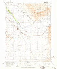
1957 Map of Battle Mountain
USGS Topo · Published 1959About this map
The Humboldt River and the competing routes of the Southern Pacific and Western Pacific railroads dictate the development of this Nevada corridor during the late 1950s. At the center of this network lies Battle Mountain, serving as a critical junction for regional transport and aviation at the Lander County Airport. The map documents a ranching economy sustained by complex water management, including the Gimble 1 Ditch and numerous artesian wells that dot the arid landscape.
Find a feature on this map
74 named features on this map. Tap any name to fly to it.
Don’t see what you’re looking for? This feature index may not catch every label — zoom into the map to look around manually.
Map Details
Editions of this 1957 Battle Mountain Map
3 editions found

Other maps of this area

1932 · Sonoma Range
USGS Topo · 1:250,000

1939 · Sonoma Range
USGS Topo · 1:250,000

1940 · Antler Peak
USGS Topo · 1:62,500

1943 · Antler Peak
USGS Topo · 1:62,500

1949 · Crescent Valley
USGS Topo · 1:62,500

1949 · Mt. Lewis
USGS Topo · 1:62,500

1950 · Mt. Lewis
USGS Topo · 1:62,500

1950 · Crescent Valley
USGS Topo · 1:62,500

1955 · Winnemucca
USGS Topo · 1:250,000

1957 · Dunphy
USGS Topo · 1:62,500