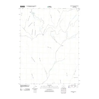
2010 Map of Baxter Pass
USGS Topo · Published 2010About this map
Atchee serves as a central point of interest in this high-altitude landscape where Garfield County terrain meets the drainage networks of the western slope. The topography is defined by a dense system of canyons and gulches, including Railroad Canyon and Wagon Canyon, which trace the historical routes through this challenging geography. In the northern portion of the sheet, the Baxter Dam contains the waters of Baxter Reservoir, while the surrounding slopes are etched with numerous drainages like West Fork Sawmill Gulch and East Fork Sawmill Gulch. The elevation transitions are marked by Baxter Pass, a critical point for the roads that navigate between the steep-walled canyons such as Hells Hole Canyon and Buttermilk Canyon. The network of names suggests a history of timber extraction and transport, evidenced by labels like Sawmill Gulch and the winding course of Baxter Pass Rd.
Find a feature on this map
31 named features on this map. Tap any name to fly to it.
Don’t see what you’re looking for? This feature index may not catch every label — zoom into the map to look around manually.
Map Details
Editions of this 2010 Baxter Pass Map
This is the sole edition of this map. No revisions or reprints were ever made.
Other maps of this area

1885 · East Tavaputs
USGS Topo · 1:250,000

1956 · Grand Junction
USGS Topo · 1:250,000

1959 · Grand Junction
USGS Topo · 1:250,000

1960 · Grand Junction
USGS Topo · 1:250,000

1962 · Grand Junction
USGS Topo · 1:250,000

1964 · Grand Junction
USGS Topo · 1:250,000

1964 · Douglas Pass
USGS Topo · 1:24,000

1964 · East Evacuation Creek
USGS Topo · 1:24,000

1964 · Baxter Pass
USGS Topo · 1:24,000
1964 · Big Foundation Creek
USGS Topo · 1:24,000