
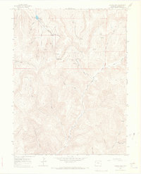
1964 Map of Baxter Pass
USGS Topo · Published 1968About this map
Atchee sits at the base of a complex drainage network where Railroad Canyon and Wagon Canyon converge into the winding course of Salt Creek. This 1964 field-checked survey illustrates a high-desert landscape defined by industrial utility and natural water sources, featuring a prominent pipeline and numerous vital water points like Columbine Spring and McAndrews Lake. The presence of Railroad Canyon and a network of jeep trails reflects the area's history of logistics and transportation through the steep terrain leading up to Baxter Pass. Geologic and energy exploration is evident through markers for a Gas Well and several drill holes scattered among the deep cuts of Snow Grove Canyon and Sawmill Gulch. This map provides a clear record of the intersection between Colorado's resource extraction infrastructure and its demanding physical geography.
Find a feature on this map
37 named features on this map. Tap any name to fly to it.
Don’t see what you’re looking for? This feature index may not catch every label — zoom into the map to look around manually.
Map Details
Editions of this 1964 Baxter Pass Map
2 editions found
Other maps of this area

1885 · East Tavaputs
USGS Topo · 1:250,000

1956 · Grand Junction
USGS Topo · 1:250,000

1959 · Grand Junction
USGS Topo · 1:250,000

1960 · Grand Junction
USGS Topo · 1:250,000

1962 · Grand Junction
USGS Topo · 1:250,000

1964 · Grand Junction
USGS Topo · 1:250,000

1964 · Douglas Pass
USGS Topo · 1:24,000

1964 · East Evacuation Creek
USGS Topo · 1:24,000
1964 · Big Foundation Creek
USGS Topo · 1:24,000

1965 · Grand Junction
USGS Topo · 1:250,000