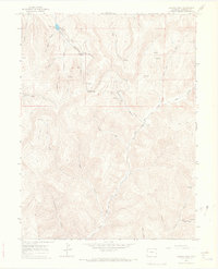
1964 Map of Baxter Pass
USGS Topo · Published 1968About this map
Baxter Pass serves as the topographic centerpiece of this 1960s study, marking a high divide where the drainages of Evacuation Creek and Salt Creek diverge. The map reveals a landscape defined by deep canyons and industrial infrastructure, including a prominent Pipeline that cuts across the high country near Columbine Spring. At the base of the pass, the settlement of Atchee occupies a narrow valley floor, positioned along a marked railroad grade that historically connected this remote Garfield County region. The presence of a Gas Well and Drill Hole markers near Wagon Canyon reflects the era's focus on resource extraction within the intricate network of drainage systems like Bittermilk Canyon and Hells Hole Canyon. Local landmarks such as McAndrews Lake and a Radio Tower provide specific points of orientation for those studying the mid-century development of these Colorado uplands.
Find a feature on this map
30 named features on this map. Tap any name to fly to it.
Don’t see what you’re looking for? This feature index may not catch every label — zoom into the map to look around manually.
Map Details
Editions of this 1964 Baxter Pass Map
2 editions found
Other maps of this area

1885 · East Tavaputs
USGS Topo · 1:250,000

1956 · Grand Junction
USGS Topo · 1:250,000

1959 · Grand Junction
USGS Topo · 1:250,000

1960 · Grand Junction
USGS Topo · 1:250,000

1962 · Grand Junction
USGS Topo · 1:250,000

1964 · Grand Junction
USGS Topo · 1:250,000

1964 · Douglas Pass
USGS Topo · 1:24,000

1964 · East Evacuation Creek
USGS Topo · 1:24,000

1964 · Baxter Pass
USGS Topo · 1:24,000
1964 · Big Foundation Creek
USGS Topo · 1:24,000