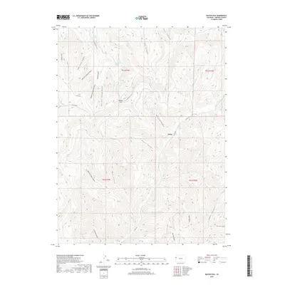
2019 Map of Baxter Pass
USGS Topo · Published 2019About this map
Atchee sits as a primary point of interest in this high-altitude landscape of Garfield County, marking a location historically tied to the treacherous mountain crossings of western Colorado. The map centers on the formidable Baxter Pass, where the drainage divide separates the waters of Bitter Creek and W Salt Cr. A complex network of steep drainages, including Railroad Canyon and Wagon Canyon, suggests the difficulty of early transportation through this corridor. Evidence of natural water sources like Columbine Spring and the Baxter Reservoir highlight the necessity of water management in this arid, dissected terrain. The land is heavily carved by numerous gulches, such as Sawmill Gulch and Buttermilk Canyon, while the dramatic Hells Hole Canyon terminates in the southeast, illustrating the deeply eroded geology of the Book Cliffs region.
Find a feature on this map
34 named features on this map. Tap any name to fly to it.
Don’t see what you’re looking for? This feature index may not catch every label — zoom into the map to look around manually.
Map Details
Editions of this 2019 Baxter Pass Map
This is the sole edition of this map. No revisions or reprints were ever made.
Other maps of this area

1885 · East Tavaputs
USGS Topo · 1:250,000

1956 · Grand Junction
USGS Topo · 1:250,000

1959 · Grand Junction
USGS Topo · 1:250,000

1960 · Grand Junction
USGS Topo · 1:250,000

1962 · Grand Junction
USGS Topo · 1:250,000

1964 · Grand Junction
USGS Topo · 1:250,000

1964 · Douglas Pass
USGS Topo · 1:24,000

1964 · East Evacuation Creek
USGS Topo · 1:24,000

1964 · Baxter Pass
USGS Topo · 1:24,000
1964 · Big Foundation Creek
USGS Topo · 1:24,000