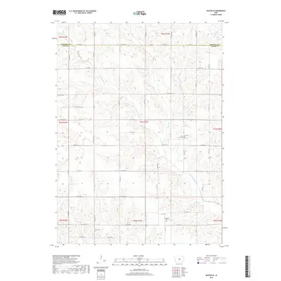
2018 Map of Baxter SE
USGS Topo · Published 2018About this map
The North Skunk River and its tributary system dominate this portion of the Iowa landscape along the border of Marshall and Jasper counties. The terrain is defined by the winding paths of Snipe Cr, Cherry Cr, and Little Snipe Cr, which carve through the rural township sections. This area preserves a high density of early pioneer and community burial sites, providing significant data for genealogical research. These include the Bethany Cem in the northwest and Wittenberg Cem in the south, alongside the Saint Johns Cem and Zoar Cem located near the eastern boundary. The road network, including Hwy F 17 W and Cty F17, follows the established section lines, intersecting the natural flow of the waterways and connecting the scattered farmsteads and rural landmarks like Linder Cem.
Find a feature on this map
42 named features on this map. Tap any name to fly to it.
Don’t see what you’re looking for? This feature index may not catch every label — zoom into the map to look around manually.
Map Details
Editions of this 2018 Baxter SE Map
This is the sole edition of this map. No revisions or reprints were ever made.
Other maps of this area

1954 · Des Moines
USGS Topo · 1:250,000

1956 · Des Moines
USGS Topo · 1:250,000

1957 · Des Moines
USGS Topo · 1:250,000

1965 · Newton
USGS Topo · 1:24,000

1965 · Colfax
USGS Topo · 1:24,000

1969 · Des Moines
USGS Topo · 1:250,000

1975 · Rhodes
USGS Topo · 1:24,000
1975 · Baxter
USGS Topo · 1:24,000
1975 · Melbourne
USGS Topo · 1:24,000

1975 · Baxter SE
USGS Topo · 1:24,000