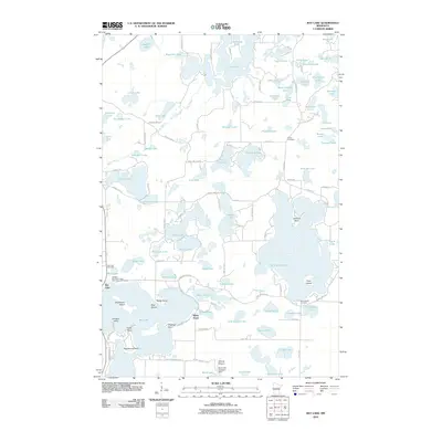
2010 Map of Bay Lake
USGS Topo · Published 2010About this map
Farm Island Lake and Bay Lake dominate this Crow Wing County landscape, where recreation and aviation have shaped the local character. Along the southwestern shores of Bay Lake, Ruttger's (Bay Lake Lodge) and Alec's Nine Golf Course mark a long-standing tradition of Northwoods tourism. The map detail highlights unique transport features like the Birch Lake Seaplane Base and Sethney Stolport, reflecting the importance of private aviation in accessing these interconnected water bodies.
Find a feature on this map
110 named features on this map. Tap any name to fly to it.
Don’t see what you’re looking for? This feature index may not catch every label — zoom into the map to look around manually.
Map Details
Editions of this 2010 Bay Lake Map
This is the sole edition of this map. No revisions or reprints were ever made.
Other maps of this area

1912 · Deerwood
USGS Topo · 1:62,500

1913 · Cuyuna
USGS Topo · 1:62,500

1914 · Deerwood
USGS Topo · 1:62,500

1914 · Aitkin
USGS Topo · 1:62,500

1915 · Aitkin
USGS Topo · 1:62,500

1915 · Cuyuna
USGS Topo · 1:62,500

1916 · Wealthwood
USGS Topo · 1:62,500

1953 · Duluth
USGS Topo · 1:250,000

1958 · Duluth
USGS Topo · 1:250,000

1973 · Iron Hub
USGS Topo · 1:24,000