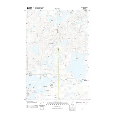
2013 Map of Bay Lake
USGS Topo · Published 2013About this map
Bay Lake dominates the southwestern portion of this Central Minnesota landscape, characterized by an intricate network of glacial lakes and points. The settlement of Bennettville sits at the junction of Tame Fish Lake Rd near its namesake Bennettville Cem. This area, split by the Crow Wing and Aitkin county line, shows a developed recreation and residential footprint integrated with the natural geography. Notable landmarks include Ruttger's Bay Lake Lodge and the Sethney Airport, serving the numerous seasonal and permanent residences clustered around bodies of water like Cedar Lake and Thornton Lake. Local genealogy is anchored by sites such as Bay Lake Cem and Dorris Cem, while the lakefront is defined by distinct projections including Battle Point, Eaglewood Point, and Brighton Point.
Find a feature on this map
123 named features on this map. Tap any name to fly to it.
Don’t see what you’re looking for? This feature index may not catch every label — zoom into the map to look around manually.
Map Details
Editions of this 2013 Bay Lake Map
This is the sole edition of this map. No revisions or reprints were ever made.
Other maps of this area

1912 · Deerwood
USGS Topo · 1:62,500

1913 · Cuyuna
USGS Topo · 1:62,500

1914 · Deerwood
USGS Topo · 1:62,500

1914 · Aitkin
USGS Topo · 1:62,500

1915 · Aitkin
USGS Topo · 1:62,500

1915 · Cuyuna
USGS Topo · 1:62,500

1916 · Wealthwood
USGS Topo · 1:62,500

1953 · Duluth
USGS Topo · 1:250,000

1958 · Duluth
USGS Topo · 1:250,000

1973 · Iron Hub
USGS Topo · 1:24,000