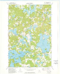
1973 Map of Bay Lake
USGS Topo · Published 1976About this map
Glacial lakes and wetlands define the border between Deerwood, Farm Island, and Hazelton townships in the early 1970s. The landscape is dominated by the irregular shorelines of Bay Lake and its numerous named points, including Malkerson Island, Battle Point, and Eaglewood Point. To the north, the Burlington Northern line and an Old Railroad Grade track through the timbered terrain, reflecting the area's history of rail transport and resource extraction, evidenced by several Gravel Pits scattered near the Crow Wing and Aitkin County line.
Find a feature on this map
81 named features on this map. Tap any name to fly to it.
Don’t see what you’re looking for? This feature index may not catch every label — zoom into the map to look around manually.
Map Details
Editions of this 1973 Bay Lake Map
This is the sole edition of this map. No revisions or reprints were ever made.
Other maps of this area

1912 · Deerwood
USGS Topo · 1:62,500

1913 · Cuyuna
USGS Topo · 1:62,500

1914 · Deerwood
USGS Topo · 1:62,500

1914 · Aitkin
USGS Topo · 1:62,500

1915 · Aitkin
USGS Topo · 1:62,500

1915 · Cuyuna
USGS Topo · 1:62,500

1916 · Wealthwood
USGS Topo · 1:62,500

1953 · Duluth
USGS Topo · 1:250,000

1958 · Duluth
USGS Topo · 1:250,000

1973 · Iron Hub
USGS Topo · 1:24,000