Loading...
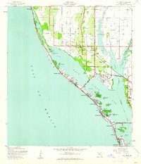
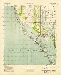
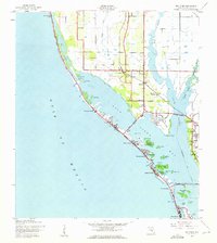
Loading map...1943 Map of Bay Pines
USGS Topo · Published 1961About this map
Boca Ciega Bay dominates this coastal landscape during the early 1940s, separating the developing Pinellas peninsula from the barrier islands of Sand Key and Treasure Island. The area shows a burgeoning residential and institutional footprint, centered around the sprawling V A Hospital at Bay Pines. Inland, the rural character of Seminole is anchored by the Seminole Sch and Seminole Ch, while the Seaboard Air Line railroad provides a vital transportation link via the Bay Pines (Station).
Find a feature on this map
52 named features on this map. Tap any name to fly to it.
Don’t see what you’re looking for? This feature index may not catch every label — zoom into the map to look around manually.
Map Details
Date Portrayed1943
Date Published1961
PublisherU.S. Geological Survey
Map TypeTopographic
Scale1:24,000
Physical Dimensions22.93 x 26.75 inches
Editions of this 1943 Bay Pines Map
3 editions found
Historical Maps of Saint Petersburg Through Time
1 maps found
Featured Locations
Source Details
SourceU.S. Geological Survey
CopyrightPublic Domain