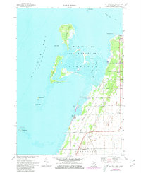
1970 Map of Bay Port West
USGS Topo · Published 1980About this map
Saginaw Bay and the interconnected waters of Wild Fowl Bay dominate this coastal landscape, where the shoreline is defined by a complex network of islands and marshes. The village of Bay Port serves as the primary upland settlement, supported by the Chesapeake and Ohio railroad line running parallel to the coast. This 1970 snapshot of the shoreline shows an area managed for conservation, with a significant State Wildlife Area covering the shallow waters and wetlands around the Middle Grounds.
Find a feature on this map
55 named features on this map. Tap any name to fly to it.
Don’t see what you’re looking for? This feature index may not catch every label — zoom into the map to look around manually.
Map Details
Editions of this 1970 Bay Port West Map
2 editions found
Other maps of this area

1954 · Flint
USGS Topo · 1:250,000

1958 · Flint
USGS Topo · 1:250,000

1963 · Fish Point
USGS Topo · 1:24,000

1963 · Owendale
USGS Topo · 1:24,000

1963 · Sebewaing
USGS Topo · 1:24,000

1970 · Bay Port West
USGS Topo · 1:24,000

1970 · Bay Port East
USGS Topo · 1:24,000

1970 · Caseville
USGS Topo · 1:24,000

1970 · Sand Point
USGS Topo · 1:24,000
1984 · Bay City
USGS Topo · 1:100,000