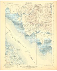
1931 Map of Bay Side
USGS Topo · Published 1931About this map
Cohansey Creek snakes through the tidal marshes of Cumberland and Greenwich in this 1931 edition, which details the maritime and agricultural life of the lower Delaware River. Inland, the map reveals a landscape defined by small mill operations and rural centers like Shiloh and Roadstown. Significant industrial and navigational markers include Sheppard Mills and Laning Wharf, illustrating how local commerce relied on both the Southern Jersey R R and the surrounding waterways. Across the river on Bombay Hook Island, the survey captures the complex drainage systems of Bear Swamp and Leatherberry Flats. Navigational safety for the bay's traffic is anchored by the Cohansey Light Old Light and the offshore Ship John Light, marking the transition from river to bay. This survey combines 19th-century topography with 1920s revisions and early aerial photography from the U.S. Army Air Corps.
Find a feature on this map
98 named features on this map. Tap any name to fly to it.
Don’t see what you’re looking for? This feature index may not catch every label — zoom into the map to look around manually.
Map Details
Editions of this 1931 Bay Side Map
2 editions found
Other maps of this area

1890 · Salem
USGS Topo · 1:62,500

1890 · Maurice Cove
USGS Topo · 1:62,500

1890 · Bay Side
USGS Topo · 1:62,500

1890 · Bridgeton
USGS Topo · 1:62,500

1890 · Glassboro
USGS Topo · 1:62,500

1891 · Maurice Cove
USGS Topo · 1:62,500

1894 · Bay Side
USGS Topo · 1:62,500

1894 · Bridgeton
USGS Topo · 1:62,500

1898 · Salem
USGS Topo · 1:62,500

1898 · Glassboro
USGS Topo · 1:62,500