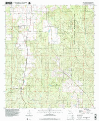
1994 Map of Bay Springs
USGS Topo · Published 1998About this map
The settlement of Bay Springs and the nearby locale of McKinnon anchor this rural landscape in northern Escambia County. The topography is defined by an intricate network of waterways draining toward the east and south, including Pine Barren Creek and Little Pine Barren Creek, while the western portion is shaped by the forks of Boggy Creek. Much of the eastern terrain is dedicated to the Champion International State Wildlife Management Area, indicating a landscape managed for timber and conservation rather than dense residential development. Small-scale industrial activity is evident through a Claypit and Sandpit in the northwest and southwest corners, respectively. Genealogists may find value in the presence of a local Cem near the headwaters of Still Branch, which winds through the southern timberlands toward Alligator Pond.
Find a feature on this map
16 named features on this map. Tap any name to fly to it.
Don’t see what you’re looking for? This feature index may not catch every label — zoom into the map to look around manually.
Map Details
Editions of this 1994 Bay Springs Map
2 editions found
Other maps of this area

1920 · Robertsdale
USGS Topo · 1:62,500

1921 · Muscogee
USGS Topo · 1:62,500

1941 · Muscogee
USGS Topo · 1:62,500

1941 · Robertsdale
USGS Topo · 1:62,500

1941 · Century
USGS Topo · 1:62,500

1942 · Dyas
USGS Topo · 1:62,500

1943 · Robertsdale
USGS Topo · 1:62,500

1943 · Muscogee
USGS Topo · 1:62,500

1943 · Century
USGS Topo · 1:62,500

1944 · Dyas
USGS Topo · 1:62,500