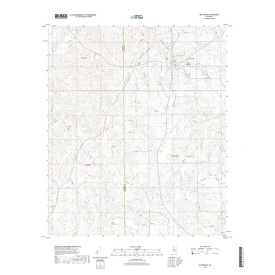
2018 Map of Bay Springs
USGS Topo · Published 2018About this map
Bay Springs serves as the focal point for this survey, situated at the boundary between Jasper and Smith counties. The landscape is defined by a dense network of waterways, including Etahoma Cr and Thompson Mill Cr, which drain the rolling terrain of eastern Mississippi. Local history and genealogy are well-represented by several family and community landmarks, such as McCraw Cem and New Zion Cem, providing a record of the area's established burial grounds and settlement patterns. The town's layout shows development concentrated along several main routes like Henry Rd and N Pine Ave, while the surrounding rural sections remain characterized by agricultural land and small drainage basins like Lick Br.
Find a feature on this map
81 named features on this map. Tap any name to fly to it.
Don’t see what you’re looking for? This feature index may not catch every label — zoom into the map to look around manually.
Map Details
Editions of this 2018 Bay Springs Map
This is the sole edition of this map. No revisions or reprints were ever made.
Other maps of this area

1953 · Hattiesburg
USGS Topo · 1:250,000

1953 · Meridian
USGS Topo · 1:250,000

1957 · Meridian
USGS Topo · 1:250,000

1958 · Hattiesburg
USGS Topo · 1:250,000

1964 · Moss
USGS Topo · 1:24,000

1964 · Lake Como
USGS Topo · 1:24,000

1965 · Meridian
USGS Topo · 1:250,000

1968 · Louin
USGS Topo · 1:24,000

1968 · Louin SW
USGS Topo · 1:24,000
1970 · Montrose South
USGS Topo · 1:24,000