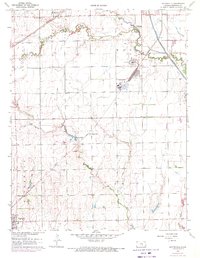
1961 Map of Bayneville
USGS Topo · Published 1971About this map
Cowskin Creek and its various tributaries, including Dry Creek, define the landscape of south-central Kansas in this detailed 1961 survey. The agrarian economy is anchored by the Atchison Topeka and Santa Fe and Missouri Pacific railroads, which connect small settlements like Schulte, Oatville, and Bayneville. Near the Murray Gill station, industrial infrastructure including a Power Plant, a Grain Elevator, and Sewage Disposal ponds reflect the mid-century development of the region. Local community life is evidenced by the Greenwood Cem, Oatville Sch, and a Townhall. Notable landmarks such as an Airway Beacon and a Landing Strip suggest the importance of regional aviation and navigation. The 1970 photorevisions highlight shifting land use, including new residential patterns and Oil Well locations near the Floodway.
Find a feature on this map
28 named features on this map. Tap any name to fly to it.
Don’t see what you’re looking for? This feature index may not catch every label — zoom into the map to look around manually.
Map Details
Editions of this 1961 Bayneville Map
3 editions found
Other maps of this area

1889 · Cheney
USGS Topo · 1:125,000

1889 · Wichita
USGS Topo · 1:125,000

1889 · Caldwell
USGS Topo · 1:125,000

1890 · Wellington
USGS Topo · 1:125,000

1891 · Cheney
USGS Topo · 1:125,000

1893 · Caldwell
USGS Topo · 1:125,000

1894 · Wichita
USGS Topo · 1:125,000

1897 · Caldwell
USGS Topo · 1:125,000

1901 · Cheney
USGS Topo · 1:125,000

1943 · Wichita West
USGS Topo · 1:31,680