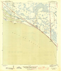
1944 Map of Beacon Hill
USGS Topo · Published 1944About this map
The coastline of the Florida Panhandle is defined here by the intricate shoreline of the Gulf of Mexico, as surveyed by S. L. Parker for the War Department. Small clusters of coastal activity at Davis Beach and Beacon Hill sit alongside the narrow strip of land separating the open gulf from the sheltered waters of St Andrews Sound and St Joseph Bay. The interior is dominated by the expansive wetlands of Wetappaswamp, where family-named water features like Joe Lamb Branch, Gude Br, and Preacher Bryant Ponds mark the drainage patterns through the marshy terrain.
Find a feature on this map
18 named features on this map. Tap any name to fly to it.
Don’t see what you’re looking for? This feature index may not catch every label — zoom into the map to look around manually.
Map Details
Editions of this 1944 Beacon Hill Map
3 editions found
Other maps of this area

1943 · Port St. Joe
USGS Topo · 1:31,680

1943 · Overstreet
USGS Topo · 1:31,680

1943 · Crooked Island
USGS Topo · 1:31,680

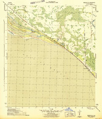
1944 · Beacon Hill
USGS Topo · 1:31,680

1944 · Long Point
USGS Topo · 1:31,680

1945 · Allanton
USGS Topo · 1:31,680

1945 · Wetappo Creek
USGS Topo · 1:31,680

1945 · St Joseph Point
USGS Topo · 1:31,680

1947 · Allanton
USGS Topo · 1:25,000

1949 · Apalachicola
USGS Topo · 1:250,000