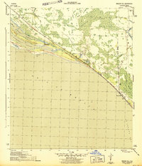
1944 Map of Beacon Hill
USGS Topo · Published 1944About this map
St Andrews Sound and the narrow barrier of Crooked Island dominate this mid-century coastal survey, reflecting the landscape of the Florida Panhandle during the Second World War. The terrain is characterized by a complex network of coastal wetlands and waterways, including the Gude Waterway and Wild Goose Lagoon. Small, isolated settlements like Davis Beach and Beacon Hill are linked by the coastal corridor of Route 98, which follows the shoreline through the transition from Gulf and Bay Counties.
Find a feature on this map
19 named features on this map. Tap any name to fly to it.
Don’t see what you’re looking for? This feature index may not catch every label — zoom into the map to look around manually.
Map Details
Editions of this 1944 Beacon Hill Map
3 editions found
Other maps of this area

1943 · Port St. Joe
USGS Topo · 1:31,680

1943 · Overstreet
USGS Topo · 1:31,680

1943 · Crooked Island
USGS Topo · 1:31,680

1944 · Beacon Hill
USGS Topo · 1:31,680

1944 · Long Point
USGS Topo · 1:31,680

1945 · Allanton
USGS Topo · 1:31,680

1945 · Wetappo Creek
USGS Topo · 1:31,680

1945 · St Joseph Point
USGS Topo · 1:31,680

1947 · Allanton
USGS Topo · 1:25,000

1949 · Apalachicola
USGS Topo · 1:250,000