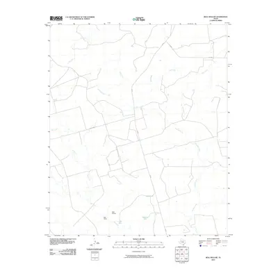
2010 Map of Beal Hollow
USGS Topo · Published 2010About this map
Beal Hollow defines this corner of Garza County, where a sparse network of ranch roads and water tanks reveals the infrastructure of West Texas land management. The drainage patterns of Little Bull Creek and Bull Creek dominate the southern half of the map, while the northern section is marked by the winding courses of Salt Creek and Sand Creek. This 2010 survey shows the intersection of modern state routes like FM 669 with established local thoroughfares such as John Dennis Rd. Human presence in this arid landscape is most visible through the strategic placement of water resources, including White Tank, Highway Tank, and Cliff Tank, which serve as critical landmarks for local land use and navigation.
Find a feature on this map
12 named features on this map. Tap any name to fly to it.
Don’t see what you’re looking for? This feature index may not catch every label — zoom into the map to look around manually.
Map Details
Editions of this 2010 Beal Hollow Map
This is the sole edition of this map. No revisions or reprints were ever made.
Other maps of this area

1954 · Lubbock
USGS Topo · 1:250,000

1954 · Big Spring
USGS Topo · 1:250,000

1958 · Big Spring
USGS Topo · 1:250,000

1969 · Gail NE
USGS Topo · 1:24,000

1969 · Beal Hollow
USGS Topo · 1:24,000

1969 · Indian Canyon NE
USGS Topo · 1:24,000

1969 · Gail
USGS Topo · 1:24,000

1969 · Grassland SE
USGS Topo · 1:24,000

1969 · Cooper Creek
USGS Topo · 1:24,000
1969 · Middle Creek
USGS Topo · 1:24,000