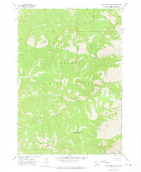
1962 Map of Bear Creek Point
USGS Topo · Published 1975About this map
Bear Creek Point dominates the southern landscape of this Idaho interior, serving as the site for the Lookout Bear Creek Point. This high-altitude vantage point overlooks the transition between the Salmon National Forest and the Boise National Forest, demarcated by the Boise National Forest Boundary. The drainage patterns here are complex and well-defined, with the Middle Fk Salmon R skirting the southeastern corner. Numerous steep drainages such as Bernard Creek, Paradise Creek, and Brush Creek carve through the high country. The convergence of these waterways, including the forks of Sheep Creek and the deep Countess Gulch, illustrates the dramatic vertical relief of the region before it reaches the larger river systems. This 1962 survey provides an exacting record of the wilderness topography across the Valley and Lemhi county line.
Find a feature on this map
21 named features on this map. Tap any name to fly to it.
Don’t see what you’re looking for? This feature index may not catch every label — zoom into the map to look around manually.
Map Details
Editions of this 1962 Bear Creek Point Map
2 editions found
Other maps of this area

1930 · Casto
USGS Topo · 1:125,000

1956 · Elk City
USGS Topo · 1:250,000

1957 · Challis
USGS Topo · 1:250,000

1960 · Elk City
USGS Topo · 1:250,000

1960 · Challis
USGS Topo · 1:250,000

1962 · Mormon Mtn
USGS Topo · 1:24,000

1962 · Bear Creek Point
USGS Topo · 1:24,000

1962 · Puddin Mtn
USGS Topo · 1:24,000

1962 · Norton Ridge
USGS Topo · 1:24,000

1962 · Shellrock Peak
USGS Topo · 1:24,000