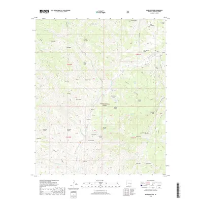
2018 Map of Bear Mountain
USGS Topo · Published 2018About this map
The Blue River carves through the heart of the Apache National Forest in this Greenlee County landscape, defining a region of steep drainages and flat-topped mesas. The map documents an area where early utility and industry left their mark through routes like the Telephone Short Cut and the path of the Old Sawmill. Notable water sources, essential for both cattle and early travelers in this arid environment, include Thomas Lake, White Oak Spring, and Sweetie Spring. High points such as Bear Mtn and Waynick Mtn overlook numerous named canyons, including Grapevine Canyon and Sawmill Canyon. The presence of landmarks like Ice Cream Cone and Telephone Ridge suggests a landscape named by local ranchers and early forest rangers. The land is divided into various blocks such as Grant Creek Mesa and Fishhook Mesa, providing a detailed look at the complex topography of the Arizona-New Mexico border region.
Find a feature on this map
78 named features on this map. Tap any name to fly to it.
Don’t see what you’re looking for? This feature index may not catch every label — zoom into the map to look around manually.
Map Details
Editions of this 2018 Bear Mountain Map
This is the sole edition of this map. No revisions or reprints were ever made.
Other maps of this area

1913 · Morenci
USGS Topo · 1:125,000

1915 · Morenci
USGS Topo · 1:125,000

1922 · Nutrioso
USGS Topo · 1:125,000

1954 · Clifton
USGS Topo · 1:250,000

1957 · Clifton
USGS Topo · 1:250,000

1958 · Clifton
USGS Topo · 1:250,000

1958 · Hannagan Meadow
USGS Topo · 1:62,500

1961 · Blue
USGS Topo · 1:62,500

1962 · Clifton
USGS Topo · 1:250,000
1967 · Alma Mesa
USGS Topo · 1:24,000