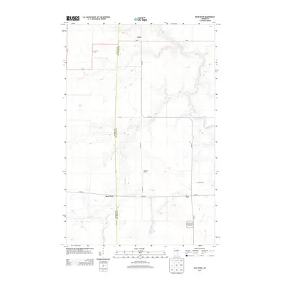
2013 Map of Bear River
USGS Topo · Published 2013About this map
The border of Itasca and St. Louis counties defines the central axis of this landscape, where the northern Minnesota woodlands transition toward the Superior National Forest. This 2013 survey records the small settlements of Bear River and Celina, connected by the corridor of MN-1 and Co HWY-5. The region is defined by a dense network of waterways, including the winding Sturgeon River and Bear River, which are fed by smaller tributaries like Stony Brook and Bear River Creek. Local history and genealogy are preserved in the locations of the Carpenter Cem and Morcom Cem, while the Anderson Airport provides a modern aviation landmark in an area otherwise characterized by rural township roads and forestry tracts.
Find a feature on this map
19 named features on this map. Tap any name to fly to it.
Don’t see what you’re looking for? This feature index may not catch every label — zoom into the map to look around manually.
Map Details
Editions of this 2013 Bear River Map
This is the sole edition of this map. No revisions or reprints were ever made.
Other maps of this area

1954 · Hibbing
USGS Topo · 1:250,000

1955 · Dewey Lake NW
USGS Topo · 1:24,000

1957 · Hibbing
USGS Topo · 1:250,000

1958 · Hibbing
USGS Topo · 1:250,000

1964 · Hibbing
USGS Topo · 1:250,000

1964 · Side Lake
USGS Topo · 1:24,000

1964 · Gheen NW
USGS Topo · 1:24,000
1964 · Meadow Brook
USGS Topo · 1:24,000

1964 · Sherry Lake
USGS Topo · 1:24,000

1970 · Rauch
USGS Topo · 1:24,000