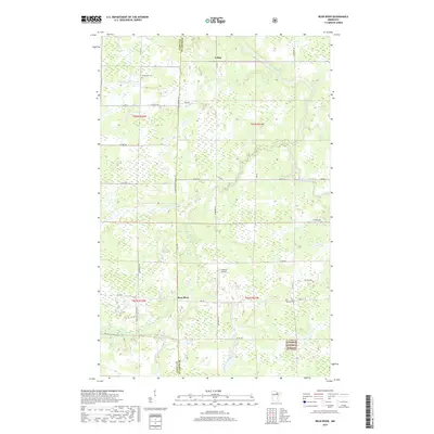
2019 Map of Bear River
USGS Topo · Published 2019About this map
Bear River and Celina sit along the border of Itasca and St. Louis counties, serving as small community hubs in a landscape defined by northern forests and meandering waterways. The Sturgeon River flows across the northern section, while the southern reaches are marked by the presence of the Superior National Forest. This 2019 survey documents the rural road network connecting isolated farmsteads and timberlands via routes like Co Hwy 5 and the St Louis Itasca Judicial Rd. Local history is anchored at Carpenter Cem near the northern edge and Morcom Cem to the south, while Anderson Airport provides a modern utility point in the center of the quadrangle. Small tributaries like Stony Brook and Bear River Cr feed into the regional drainage, reflecting the wet, marshy character typical of this part of Minnesota.
Find a feature on this map
37 named features on this map. Tap any name to fly to it.
Don’t see what you’re looking for? This feature index may not catch every label — zoom into the map to look around manually.
Map Details
Editions of this 2019 Bear River Map
This is the sole edition of this map. No revisions or reprints were ever made.
Other maps of this area

1954 · Hibbing
USGS Topo · 1:250,000

1955 · Dewey Lake NW
USGS Topo · 1:24,000

1957 · Hibbing
USGS Topo · 1:250,000

1958 · Hibbing
USGS Topo · 1:250,000

1964 · Hibbing
USGS Topo · 1:250,000

1964 · Side Lake
USGS Topo · 1:24,000

1964 · Gheen NW
USGS Topo · 1:24,000
1964 · Meadow Brook
USGS Topo · 1:24,000

1964 · Sherry Lake
USGS Topo · 1:24,000

1970 · Rauch
USGS Topo · 1:24,000