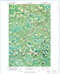
1970 Map of Bear River
USGS Topo · Published 1973About this map
The Sturgeon River meanders through a dense timber landscape along the boundary of Itasca and St. Louis counties. This 1970 orthophotomap provides a photographic perspective of the North Woods, revealing the small settlements and isolated farmsteads of Carpenter and Bearville that were established near the river's path. The area is dominated by the Sturgeon River State Forest and George Washington State Forest, where early logging and extractive efforts are evidenced by scattered Gravel Pits and narrow forest roads.
Find a feature on this map
18 named features on this map. Tap any name to fly to it.
Don’t see what you’re looking for? This feature index may not catch every label — zoom into the map to look around manually.
Map Details
Editions of this 1970 Bear River Map
This is the sole edition of this map. No revisions or reprints were ever made.
Other maps of this area

1954 · Hibbing
USGS Topo · 1:250,000

1955 · Dewey Lake NW
USGS Topo · 1:24,000

1957 · Hibbing
USGS Topo · 1:250,000

1958 · Hibbing
USGS Topo · 1:250,000

1964 · Hibbing
USGS Topo · 1:250,000

1964 · Side Lake
USGS Topo · 1:24,000

1964 · Gheen NW
USGS Topo · 1:24,000
1964 · Meadow Brook
USGS Topo · 1:24,000

1964 · Sherry Lake
USGS Topo · 1:24,000

1970 · Rauch
USGS Topo · 1:24,000