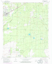
1973 Map of Bearden
USGS Topo · Published 1986About this map
The timbered lowlands of the Ouachita and Calhoun county line center on the rail-aligned community of Bearden. The St Louis Southwestern railroad corridor dictates the settlement pattern, connecting the town to rural outposts like Macedonia Church and Mt Olive Church. The landscape is a complex network of wetlands and small water bodies, including Covington Pond, North Pond, and Middle Pond, which drain into the meandering Little Champagnolle Creek. A significant portion of the southern landscape is occupied by the East Camden and Highland Abandoned Ammunition Depot, showing a vast grid of storage bunkers and service roads. Genealogists will find several family-named landmarks and burial sites such as Mossy Hill Cemetery, Harlow Cemetery, and the Hugh Jones terrain feature, reflecting the deep-rooted local history of this Arkansas river-basin region.
Find a feature on this map
44 named features on this map. Tap any name to fly to it.
Don’t see what you’re looking for? This feature index may not catch every label — zoom into the map to look around manually.
Map Details
Editions of this 1973 Bearden Map
2 editions found
Other maps of this area

1903 · Camden
USGS Topo · 1:125,000

1953 · El Dorado
USGS Topo · 1:250,000

1957 · El Dorado
USGS Topo · 1:250,000

1958 · El Dorado
USGS Topo · 1:250,000

1960 · El Dorado
USGS Topo · 1:250,000

1966 · Fordyce
USGS Topo · 1:24,000

1973 · Bearden
USGS Topo · 1:24,000
1973 · Eagle Mills
USGS Topo · 1:24,000
1973 · Holly Springs
USGS Topo · 1:24,000
1973 · East Camden
USGS Topo · 1:24,000