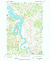
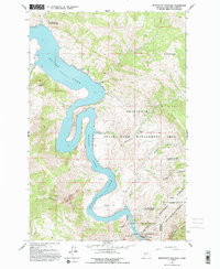
1962 Map of Beartooth Mountain
USGS Topo · Published 1984About this map
The Missouri River carves a dramatic path through this section of the Helena National Forest, defined by the deep reservoir of Holter Lake. The waterway forms a sharp Oxbow Bend beneath the rising slopes of Beartooth Mountain and Jackson Peak, illustrating the complex geological transition near the Gates of the Rocky Mountains. Human presence in this mid-century period is marked by isolated outposts such as Beartooth Ranch and Sperry Ranch, alongside the Indian Trail Lodge which suggests the area's early recreational appeal. Primitive travel routes like the Beartooth Road and various pack trails navigate the steep drainage systems of Cottonwood Creek and Elkhorn Creek, connecting remote riverside features like Ming Bar to the surrounding high country.
Find a feature on this map
22 named features on this map. Tap any name to fly to it.
Don’t see what you’re looking for? This feature index may not catch every label — zoom into the map to look around manually.
Map Details
Editions of this 1962 Beartooth Mountain Map
5 editions found
Other maps of this area

1886 · Great Falls
USGS Topo · 1:250,000

1886 · Fort Logan
USGS Topo · 1:250,000

1889 · Helena
USGS Topo · 1:250,000

1893 · Helena
USGS Topo · 1:250,000

1899 · Helena
USGS Topo · 1:250,000

1903 · Helena
USGS Topo · 1:250,000

1943 · Hogan
USGS Topo · 1:125,000

1947 · Butte
USGS Topo · 1:250,000

1948 · White Sulphur Springs
USGS Topo · 1:250,000

1954 · Great Falls
USGS Topo · 1:250,000