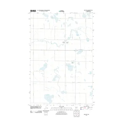
2011 Map of Beaulieu
USGS Topo · Published 2011About this map
The settlement of Beaulieu serves as a central landmark in this portion of Mahnomen County, where the meandering course of the Wild Rice River cuts through a landscape defined by glacial lakes and stream drainage. Genealogy and local history are anchored by Saint Joseph's Catholic Cemetery near the town center and another Saint Joseph's Cemetery located further south near Church Lake. The terrain is dominated by water, from the larger basins of Sandy Lake and Fish Lake to the north-running Whiskey Creek. This 2011 survey captures the established road network, including County HWY-3 and County HWY-32, which connect the rural homesteads and shorelines that characterize this region of the White Earth Reservation. The distribution of lakes like Aspinwall Lake and Chief Lake illustrates the intricate hydrology that has influenced settlement patterns and land use for generations.
Find a feature on this map
23 named features on this map. Tap any name to fly to it.
Don’t see what you’re looking for? This feature index may not catch every label — zoom into the map to look around manually.
Map Details
Editions of this 2011 Beaulieu Map
This is the sole edition of this map. No revisions or reprints were ever made.
Other maps of this area

1954 · Bemidji
USGS Topo · 1:250,000

1957 · Bemidji
USGS Topo · 1:250,000

1958 · Bemidji
USGS Topo · 1:250,000

1969 · North Twin Lake
USGS Topo · 1:24,000
1969 · Waubun
USGS Topo · 1:24,000
1969 · Ogema NE
USGS Topo · 1:24,000

1969 · Snider Lake
USGS Topo · 1:24,000
1969 · Ebro NW
USGS Topo · 1:24,000
1969 · Bejou
USGS Topo · 1:24,000
1969 · Mahnomen NE
USGS Topo · 1:24,000