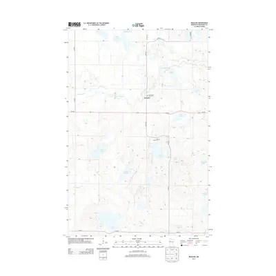
2013 Map of Beaulieu
USGS Topo · Published 2013About this map
Beaulieu is the central hub of this Mahnomen County landscape, situated where the Wild Rice River winds through a terrain densely pocketed with glacial lakes. The settlement is anchored by local landmarks such as Saint Joseph's Catholic Cem and its sister site, Saint Joseph's Cem, which serve as vital points of interest for genealogical research in this rural Minnesota community. The surrounding countryside is defined by an intricate network of water bodies, including Aspinwall Lake, Chief Lake, and Church Lake. The presence of numerous smaller features like Whiskey Cr and Little Oak Lake reflects the region's complex natural drainage. This area, largely defined by its township-and-range road grid such as 220th Ave and MN-200, illustrates the enduring agricultural and residential patterns of the White Earth Reservation vicinity in the early 21st century.
Find a feature on this map
22 named features on this map. Tap any name to fly to it.
Don’t see what you’re looking for? This feature index may not catch every label — zoom into the map to look around manually.
Map Details
Editions of this 2013 Beaulieu Map
This is the sole edition of this map. No revisions or reprints were ever made.
Other maps of this area

1954 · Bemidji
USGS Topo · 1:250,000

1957 · Bemidji
USGS Topo · 1:250,000

1958 · Bemidji
USGS Topo · 1:250,000

1969 · North Twin Lake
USGS Topo · 1:24,000
1969 · Waubun
USGS Topo · 1:24,000
1969 · Ogema NE
USGS Topo · 1:24,000

1969 · Snider Lake
USGS Topo · 1:24,000
1969 · Ebro NW
USGS Topo · 1:24,000
1969 · Bejou
USGS Topo · 1:24,000
1969 · Mahnomen NE
USGS Topo · 1:24,000