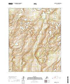
2017 Map of Beaver A-1 SE
USGS Topo · Published 2017About this map
Jefferson Cr meanders through a landscape defined by expansive wetlands and isolated water bodies in this section of the Yukon-Koyukuk Census Area. The terrain is characterized by complex hydrography, where Muddy Lake and the New Halfway Lakes chain sit amidst a network of unnamed ponds and marshes. In the southern portion of the quadrangle, Little Beaver Lake and Flat Creek Lake provide clear landmarks within the wilderness. The drainage patterns, including the W Fork Flat Cr, suggest a low-relief environment where water dominates the geography, creating a mosaic of aquatic habitats typical of the Alaskan interior. This survey serves as a precise record of the shoreline configurations and water levels during the early 21st century, illustrating the intricate relationship between the region's small lakes and their connecting seasonal creeks.
Find a feature on this map
13 named features on this map. Tap any name to fly to it.
Don’t see what you’re looking for? This feature index may not catch every label — zoom into the map to look around manually.
Map Details
Editions of this 2017 Beaver A-1 SE Map
This is the sole edition of this map. No revisions or reprints were ever made.
Other maps of this area

1945 · Livengood
USGS Topo · 1:250,000

1951 · Fort Yukon
USGS Topo · 1:250,000

1951 · Livengood
USGS Topo · 1:250,000

1951 · Beaver
USGS Topo · 1:250,000

1951 · Circle
USGS Topo · 1:250,000

1951 · Circle D-6
USGS Topo · 1:63,360

1952 · Livengood D-1
USGS Topo · 1:63,360

1954 · Circle D-6
USGS Topo · 1:63,360
1954 · Livengood D-1
USGS Topo · 1:63,360

1955 · Circle
USGS Topo · 1:250,000