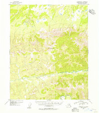
1954 Map of Livengood D-1
USGS Topo · Published 1956About this map
Mt Schwatka stands as the primary landmark in this interior Alaskan wilderness, rising above a landscape defined by sharp elevation shifts and winding watercourses. This mid-1950s survey, compiled from aerial photography, illustrates a rugged terrain devoid of established roads or settlements, where navigation relied entirely on natural landforms and surveyed peaks. The drainage patterns of the region are dominated by the westward-flowing Victoria Creek, which cuts through the central portion of the quadrangle, and Beaver Creek further south. These waterways provided the primary corridors through a territory marked by triangulation stations like VABM 2849 Victoria, points used by the Geological Survey to fix this remote topography into a systematic grid. The absence of industrial or residential labels highlights the area's status as a largely untouched frontier during the mid-twentieth century.
Find a feature on this map
5 named features on this map. Tap any name to fly to it.
Don’t see what you’re looking for? This feature index may not catch every label — zoom into the map to look around manually.
Map Details
Editions of this 1954 Livengood D-1 Map
This is the sole edition of this map. No revisions or reprints were ever made.
Other maps of this area

1945 · Livengood
USGS Topo · 1:250,000

1951 · Fort Yukon
USGS Topo · 1:250,000

1951 · Livengood
USGS Topo · 1:250,000

1951 · Beaver
USGS Topo · 1:250,000

1951 · Circle
USGS Topo · 1:250,000

1951 · Circle D-6
USGS Topo · 1:63,360

1951 · Livengood C-2
USGS Topo · 1:63,360

1951 · Livengood C-1
USGS Topo · 1:63,360

1951 · Circle C-6
USGS Topo · 1:63,360

1952 · Livengood D-2
USGS Topo · 1:63,360