
1952 Map of Livengood D-2
USGS Topo · Published 1965About this map
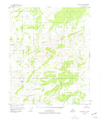
Noordor Dome stands as a prominent high point in this interior Alaskan landscape, which was documented through photogrammetric methods in the early 1950s. The topography is defined by a dense network of watercourses, including West Fork Beaver Creek in the north and the winding path of Victoria Creek to the south. A single isolated Cabin appears along a small tributary in the southeast, representing a rare sign of human presence in a region otherwise dominated by natural features. The map also records the location of a Pingo, a characteristic permafrost landform. This survey provides a window into the remote terrain north of Fairbanks as it remained during the mid-century, divided by the Fairbanks Meridian and bounded by landmarks such as Granite and Ronald. Drainage patterns from Bear Creek, Lost Creek, and Grouse Creek illustrate the complex watershed of the Yukon-Koyukuk region.
Find a feature on this map
12 named features on this map. Tap any name to fly to it.
Don’t see what you’re looking for? This feature index may not catch every label — zoom into the map to look around manually.
Map Details
Editions of this 1952 Livengood D-2 Map
2 editions found
Other maps of this area

1945 · Livengood
USGS Topo · 1:250,000

1951 · Livengood
USGS Topo · 1:250,000

1951 · Beaver
USGS Topo · 1:250,000

1951 · Livengood D-3
USGS Topo · 1:63,360

1951 · Livengood C-2
USGS Topo · 1:63,360

1951 · Livengood C-1
USGS Topo · 1:63,360

1952 · Livengood D-1
USGS Topo · 1:63,360

1954 · Livengood C-2
USGS Topo · 1:63,360

1954 · Livengood C-1
USGS Topo · 1:63,360
1954 · Livengood D-2
USGS Topo · 1:63,360