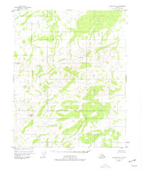
1952 Map of Livengood D-2
USGS Topo · Published 1977About this map
Noodor Grouse Dome and Ronald stand as prominent surveying benchmarks within this interior Alaskan landscape, which was mapped from aerial photography taken in 1951. The topography is defined by a dense network of drainages, including Lost Creek, Granite Creek, and Grouse Creek, which flow through terrain marked by geological features like the Pingo in the southwest and the Butte to the northwest.
Find a feature on this map
11 named features on this map. Tap any name to fly to it.
Don’t see what you’re looking for? This feature index may not catch every label — zoom into the map to look around manually.
Map Details
Editions of this 1952 Livengood D-2 Map
2 editions found
Other maps of this area

1945 · Livengood
USGS Topo · 1:250,000

1951 · Livengood
USGS Topo · 1:250,000

1951 · Beaver
USGS Topo · 1:250,000

1951 · Livengood D-3
USGS Topo · 1:63,360

1951 · Livengood C-2
USGS Topo · 1:63,360

1951 · Livengood C-1
USGS Topo · 1:63,360

1952 · Livengood D-2
USGS Topo · 1:63,360

1952 · Livengood D-1
USGS Topo · 1:63,360

1954 · Livengood C-2
USGS Topo · 1:63,360

1954 · Livengood C-1
USGS Topo · 1:63,360