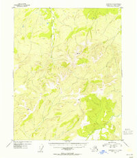
1954 Map of Livengood D-2
USGS Topo · Published 1955About this map
Lost Creek and the headwaters of Victoria Creek define this Alaskan interior landscape as it was documented in the early 1950s. The topography is marked by significant elevations, including high points at VABM Ronald 2938 and VABM Grouse 2964. While largely dominated by its river systems and ridge lines, the map identifies a solitary Cabin near the southern bend of Victoria Creek, suggesting the presence of seasonal trapping, prospecting, or wilderness residency. The drainage patterns of Grouse Creek and Bear Creek illustrate the complex watershed of the Yukon-Koyukuk region before more modern infrastructure or broader industrial development reached this specific reach of the Alaska interior.
Find a feature on this map
7 named features on this map. Tap any name to fly to it.
Don’t see what you’re looking for? This feature index may not catch every label — zoom into the map to look around manually.
Map Details
Editions of this 1954 Livengood D-2 Map
This is the sole edition of this map. No revisions or reprints were ever made.
Other maps of this area

1945 · Livengood
USGS Topo · 1:250,000

1951 · Livengood
USGS Topo · 1:250,000

1951 · Beaver
USGS Topo · 1:250,000

1951 · Livengood D-3
USGS Topo · 1:63,360

1951 · Livengood C-2
USGS Topo · 1:63,360

1951 · Livengood C-1
USGS Topo · 1:63,360

1952 · Livengood D-2
USGS Topo · 1:63,360

1952 · Livengood D-1
USGS Topo · 1:63,360

1954 · Livengood C-2
USGS Topo · 1:63,360

1954 · Livengood C-1
USGS Topo · 1:63,360