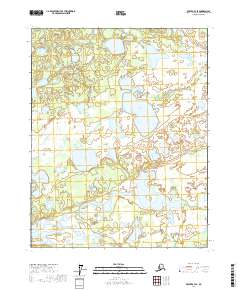
2017 Map of Beaver B-4 SE
USGS Topo · Published 2017About this map
Yukon Flats defines this portion of the interior, characterized by an intricate network of wetlands and namesake water bodies. Large, irregular features like Tulebagh Lake and Flat Lake dominate the northern and central sections, while the southern reaches are marked by Tanjoga Lake and the winding course of Meadow Cr. This 2017 survey illustrates the complex hydrography of the region, where the lack of formal roads and settlements highlights the dominance of the natural landscape. Smaller features such as Clochacohua Lake appear as isolated basins within the broader marshy terrain. The map provides a detailed record of the township and range lines, specifically within t18n r5w and t17n r6w, which serve as the primary organizational structure for this expansive wilderness area.
Find a feature on this map
10 named features on this map. Tap any name to fly to it.
Don’t see what you’re looking for? This feature index may not catch every label — zoom into the map to look around manually.
Map Details
Editions of this 2017 Beaver B-4 SE Map
This is the sole edition of this map. No revisions or reprints were ever made.
Other maps of this area

1951 · Beaver
USGS Topo · 1:250,000

1956 · Beaver B-3
USGS Topo · 1:63,360

1956 · Beaver A-3
USGS Topo · 1:63,360

1956 · Beaver
USGS Topo · 1:250,000

1956 · Beaver A-4
USGS Topo · 1:63,360

1956 · Beaver B-4
USGS Topo · 1:63,360

1964 · Beaver
USGS Topo · 1:250,000
2017 · Beaver A-3 NW
USGS Topo · 1:25,000
2017 · Beaver B-3 NW
USGS Topo · 1:25,000
2017 · Beaver B-4 NE
USGS Topo · 1:25,000