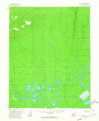
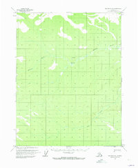
1956 Map of Beaver B-5
USGS Topo · Published 1964About this map
Long Ridge defines the northern reaches of this interior landscape, where the terrain drops sharply into a complex network of wetlands and tundra lakes. Surveyed in the mid-1950s using photogrammetric methods from aerial photographs, the map reveals a wilderness shaped by water. Large bodies such as Tishdogatumina Lake, Echoing Lake, and Savayeit Lake dominate the southern half of the sheet, illustrating the low-relief drainage patterns characteristic of the Yukon-Koyukuk region. The West Fork of The Forks meanders through the eastern section, providing a primary drainage route through the saturated lowlands. This survey captures the natural state of the Alaskan interior before modern development, offering a precise view of the hydrology and topography as it appeared during the territorial era.
Find a feature on this map
5 named features on this map. Tap any name to fly to it.
Don’t see what you’re looking for? This feature index may not catch every label — zoom into the map to look around manually.
Map Details
Editions of this 1956 Beaver B-5 Map
4 editions found
Other maps of this area

1951 · Beaver
USGS Topo · 1:250,000

1956 · Beaver A-5
USGS Topo · 1:63,360

1956 · Beaver B-5
USGS Topo · 1:63,360

1956 · Beaver
USGS Topo · 1:250,000

1956 · Beaver A-4
USGS Topo · 1:63,360

1956 · Beaver B-4
USGS Topo · 1:63,360

1964 · Beaver
USGS Topo · 1:250,000
1970 · Beaver C-6
USGS Topo · 1:63,360

1970 · Beaver B-6
USGS Topo · 1:63,360
1970 · Beaver C-5
USGS Topo · 1:63,360